We hope your visit to the island is as enjoyable as possible!
Seguin Island is located 2 1/2 miles out to sea at the mouth of the Kennebec River. As you travel, you likely to see seals and birds and other sea life on occasion. We want your trip to the island to be both enjoyable and safe. The area between Fort Popham and Seguin Island has a distinct personality and needs to be respected. On occasion sea swell, opposing wind and tides and a very strong river current can make for some challenging sea conditions for mariners transiting these waters. Seguin Island is known for being one of the foggiest places off the coast of Maine and the dense fog can be a significant factor to deal with.
Travel By Boat
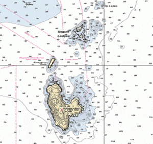
If you plan to visit Seguin in your own boat, we highly recommend the use of NOAA Chart 13295-“KENNEBEC AND SHEEPSCOT RIVER ENTRANCES”
GPS Coordinates: 43°42’26″N, 69°45’28″W
Mooring Use
Anchoring in Sequin Cove is not allowed due to the presence of under water cables. Moorings are available first come first serve for our members. Please review our mooring use guidelines.
Getting on the island
There is no dock on the island and access is only by the small beach in the cove. The beach in the cove is exposed from low to 3/4 tide. Plan to get your feet wet when landing on the island. To come ashore you will have to bring your own dinghy.
Seguin Cove and Beach
Travel By Charter
New for 2025, A charter ferry operated by RippleSmith Sailing and Capt. Shawn Mercer will be in service with two daily trips departing from Sebasco Harbor Resort in Phippsburg.
For further information visit their website at www.ripplesmithsailing.com/seguin-island-ferryling.com
Other publications with useful information on how to navigate the waters around the island are
- Roger Duncan’s A CRUISING GUIDE TO THE NEW ENGLAND COAST
- UNITED STATES COASTAL PILOT
- Maine Island Trail Association’s MITA TRAIL GUIDE


